| Total Distance: | 24 km (15 miles) 60% ascent 40% descent |
| Total time: | 2 hours |
| Skill level: | Beginner |
| Highest elevation: | 2432m (7,980 ft) |
| Lowest elevation: | 2278m (7,474 ft) |
| Surface: |
99% dirt (2-track) 1% weeds |
;)
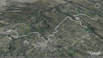
Chaquiñan Ciclovia Map
As far as I know, this is the only "Rails to Trails" bike route in Ecuador.
In the early twentieth century, Ecuador, under the guidance of president Eloy Alfaro, built an extensive passenger rail network, connecting Quito with the northern provinces, the coastal city of Guayaquil, and the southern colonial city of Cuenca. However, as happened in other countries, internal combustion replaced steam power, roads were built for cars and trucks, and the rail system fell into disrepair.
In the early twentieth century, Ecuador, under the guidance of president Eloy Alfaro, built an extensive passenger rail network, connecting Quito with the northern provinces, the coastal city of Guayaquil, and the southern colonial city of Cuenca. However, as happened in other countries, internal combustion replaced steam power, roads were built for cars and trucks, and the rail system fell into disrepair.
;)
Entrance to Ciclovia
;)
Landscaping in the Tumbaco section
Unlike North America, however, not even the freight services survived, mostly because of the high cost of maintaining rail lines in the unstable terrain of the Andes. However, the rail right of ways still exist, and the rails themselves are still more or less intact throughout many sections. Some are still maintained as tourist routes, such as the famous "Devils Nose" route from Riobamba to Alausi.
One route was between Quito and the coastal city of San Lorenzo via Ibarra, in the north.
Click to download .kml file for this route.
It was built over a period of 57 years, completd in 1962, and operated until 1998 when El Niño destroyed much of the track.
In 2003, "Vida para Quito," an environmental, pro-bike group, converted a 23-km section of the rail bed to a biking and hiking trail.
The southern entrance is in Cumbayà, an upper middle class suburb northeast of Quito. It is well-maintained, with mile markers, scenic "overlooks" and, in some sections, trailside landscaping.
;)
The Elevation Profile
It winds through upscale ("walled") communities as well as poor barrios, pastureland, forested slopes and farmland. Throughout much of the length it follows the beautiful valley of the Rio ...
There are six sections, each marked by an entrance with route information. They are named after the neighborhoods or communities they pass through: San Pedro, La Viña, La Esperanza, etc.
There are six sections, each marked by an entrance with route information. They are named after the neighborhoods or communities they pass through: San Pedro, La Viña, La Esperanza, etc.
;)
Kilometer marker
In some sections the rails are still visible, but the surface is mostly smooth with gentle grades. There are several beautiful tunnels (vintage 1920) to ride through, which add flavor and serve as reminders of the origin of this trail.
;)
Tunnel from the 1920s